Mapping

For projects that are in progress, please visit the following pages:

Mapping Projects

Technical Assistance

Follow the Floodplain Current!

Stay current on our Mapping Project by checking out our phase-specific resources.

KDA-DWR Floodplain Current-
Kickoff Edition
Map Review Edition
Appeal Period Guidance
LFD Edition
Insurance & Mitigation Edition

Base Flood Elevation Portal

The Base Flood Elevation (BFE) Portal was developed for Zone A BFE requests.  Please visit the page, register and follow the BFE Portal Quick Guide to get started.

Current Effective Floodplain Map Viewer

Use the DWR web map to view current effective digital floodplain maps, find base flood elevations, and search for letter of map changes (LOMCs).  On the Statewide DFIRM web map, please zoom into the desired location, or use the address locator tool, in order to view floodplain data.
If you need help using these maps contact the Floodplain Mapping Specialist.
DWR became a Cooperating Technical Partner with FEMA in September 1999. Through this agreement and as part of the Flood Map Modernization effort, FEMA provided funding to DWR to oversee the production of countywide digital FIRMs (DFIRMs) throughout the State of Kansas. 
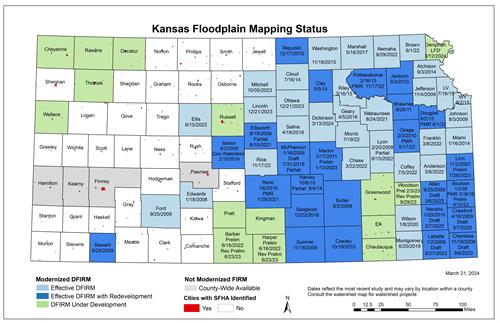
floodplain_mapping_status_03-21-2024

The Flood Map Modernization program ended in fiscal year 2008.  Mapping projects in Kansas are now funded under a new effort called Risk MAP (Mapping, Assessment, and Planning). Risk MAP provides communities with flood information and tools to enhance their mitigation plans and take action to better protect their citizens. Through more precise flood mapping products, risk assessment tools, and planning and outreach support, Risk MAP strengthens local ability to make informed decisions about reducing risk.